Surprise! The last day dawned bright and clear, we had not expected that.
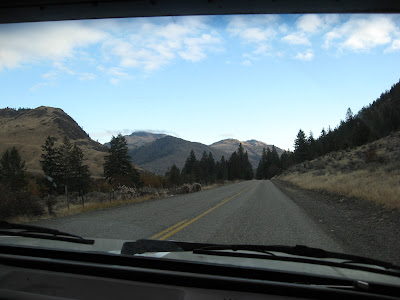
 We had plenty of time for a bit more exploring. Now that we could see mountain tops again it was worthwhile. The road we were on appeared on the map as a thin line, that we had taken to indicate gravel. The pavement was fine. Washington does good pavement, much smoother than B.C.


Anyway, we were back on our side of the line. The relaxed feel of Oroville was replaced by the busyness of Osoyoos. These towns share the lake, and are both centers for the fruit industry. But Osoyoos is a rare Southern hot spot in Canada, while Oroville is just another town in a Northern backwater. Both places are pleasant, but Osoyoos is slicker and more of a tourist trap.
Tip for people who want to enjoy Osoyoos Lake: the best place to do so is the beach park in Oroville. We stopped there once on another Washington trip, and really enjoyed it.
The next pictures are all taken from the viewpoint just East of Osoyoos.


 We had a good visit with our old friend Linda near Greenwood and were home early in the evening.

 We had plenty of time for a bit more exploring. Now that we could see mountain tops again it was worthwhile. The road we were on appeared on the map as a thin line, that we had taken to indicate gravel. The pavement was fine. Washington does good pavement, much smoother than B.C.
The map finally told us that the road type referred to jurisdiction, not surface. All those thin barely-there roads are local, not state. Do we care? The map would have told us earlier if we'd asked. We decided to drive the little loop from Tonasket into the hills and see what Nighthawk looks like. For years I have been intrigued by a turn-off from Highway 3 West of Osoyoos that announces: Nighthawk, USA, and disappears into high barren mountains.
Now we know, Nighthawk looks like this. The road there from Tonasket was really pretty and more populated than we had expected. There was ranchland and orchards, small lakes and resorts. Alas, any pictures I took were not great and were later sacrificed. Next time I must bring extra memory. East of Nighthawk it looks like this: tough terrain that still bears signs of old mine shafts.

We could have crossed into Canada now, but one more small road beckoned, from Oroville through Chesaw to Midway. Lovely landscape but the road was rough. We had to crawl, that uses more gas, Thing doesn't like being rattled either so we turned around at Chesaw, about 30 miles later. I am glad we did because the views facing West were oh WOW.

Northern Washington East of the Cascades is sparsely populated, alternating ranchland with woods. The forestry industry has been decimated here as at home. The woods are glad to get a break from unsustainable cutting, but the working people are having a tough time. At least they live in a beautiful place. The country is the place to be in an economic meltdown. There is deer to hunt (is there ever!), trout to catch, gardens can be grown, you can collect firewood to stay warm.

We crossed the border at Osoyoos after all, and were once again depressed by the general level of paranoia at borders. Chris had forgotten to have his passport ready, it was in the camper. So he just wanted to get out of the car and into the back to grab it. Panic! No sir, you must park THERE, come back throught THAT door, and then show your passport. Makes you feel like a total criminal.
Anyway, we were back on our side of the line. The relaxed feel of Oroville was replaced by the busyness of Osoyoos. These towns share the lake, and are both centers for the fruit industry. But Osoyoos is a rare Southern hot spot in Canada, while Oroville is just another town in a Northern backwater. Both places are pleasant, but Osoyoos is slicker and more of a tourist trap.
Tip for people who want to enjoy Osoyoos Lake: the best place to do so is the beach park in Oroville. We stopped there once on another Washington trip, and really enjoyed it.
The next pictures are all taken from the viewpoint just East of Osoyoos.


No comments:
Post a Comment
Comments have been set to anyone, un-moderated, and no captcha. So if you were here, wave to me? Spammers will be deleted and acquire bad karma to boot.